 by Helmholtz Association of German Research Centres
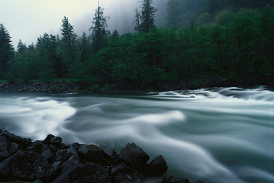
Woody debris clogging a small creek of the Ahr river, leading to temporal ponding, massive sediment deposition and overbank spillways of the flood water
by Helmholtz Association of German Research Centres
Woody debris clogging a small creek of the Ahr river, leading to temporal ponding, massive sediment deposition and overbank spillways of the flood waterCredit: M
Dietze, GFZ On 14 July 2021, between 60 and 180 mm of rain fell in the Eifel region in just 22 hours—an amount that would otherwise have fallen in several months and which led to catastrophic flooding
The events were far more destructive than existing models had predicted
Researchers at the Helmholtz Centre Potsdam—GFZ German Research Centre for Geosciences point at a number of effects that have occurred only rarely in Central Europe so far and have therefore not been taken sufficiently into account
These include, in particular, the mobilization of dead wood and sediment, both effects that are likely to become more important as climate change progresses
Michael Dietze and Ugur Öztürk report today in the journal Science on the mechanisms that have amplified the effects of the flood
They also give an outlook on a new research project that starts here in order to make future anticipation efforts more realistic
Researchers as accidental witnesses to the flood disaster 14 July is a rainy day
GFZ researcher Michael Dietze is on his way back from a field visit in the southern Eifel with colleagues from Potsdam and the University of Bonn
Heading back north, they quickly realize that what is happening just outside is more than a long heavy rain: The online data view of the Altenahr gage rises rapidly every 15 minutes, faster than the actual forecast, and faster than the researchers would have liked to, because their own measurements are affected
Flooding of the Ahr is nothing unusual: as part of a research project, Dietze and colleagues had set up several seismic stations on a three-meter-high terrace in the Ahr valley a few weeks earlier—assumed to be at safe distance to hostile flood conditions
They wanted to use them to measure ground motion caused by sediment movement and water turbulence during "regular" floods
Now the level is already one meter above the terrace, the stations are lost
Familiar effects—but from other parts of the world What the researchers were experiencing here, is only a fraction of the actual catastrophe that is taking its course in the valleys of the Ahr, Erft and Rur rivers
"The flood in the valleys of the Eifel was far more violent, faster and more unpredictable than we had previously assumed for such an event in the center of Europe," says Michael Dietze, PostDoc in the Geomorphology Section at GFZ and the Department of Geography at the University of Bonn
The causes are manifold and well known, though not from Central Europe, but rather from the deserts of the world, and from the tropics
Quickly saturated soil The rain could no longer enter the soil, which has already been saturated due to rainy weeks before
It was also too strong to run down the slopes as a thin film of water
Instead, slopes literally turned into wide rivers and transported the water not at a speed of a some centimeters, but suddenly at a few meters per second, i
e
up to a hundred times faster
This allowed it to converge into a flood wave in the actual valleys much faster
Enormous erosive power of the water In addition, the water developed enormous erosive power: On the one hand, it dug channels into the slopes and was able to flow even faster in those self-dugged pathways
On the other hand, it mobilized considerable amounts of sediment and dead wood
Once in the main valleys, the tree trunks and branches drifted towards bridges
There they became entangled and led to so-called blockages
As a result, the runoff was impeded, the water dammed up and also inundated more distal areas
Owner showing the water level of the 14 July flood on his house in Walporzheim
Note the 2
2 m water mark of the 1804 flood and the 0
6 m mark from 2016 for comparison
Credit: Michael Dietze, GFZ Unexpected effects at gravel pits and roads In the course of these events, effects and so-called coupled hazards arose that had previously not been thought possible in the region
The Erft, normally five meters wide, rose beyond its banks near the town of Blessem and poured over a field directly into a gravel pit
The edge of that pit cut its way upstream towards Blessem over a length of 300 meters, like a wandering waterfall
It undermined the first houses and led to their collapse
The road through Blessem also became a river, which—starting at the unpaved edges—undermined the road's foundation, leaving only the sewage pipes behind
This erosion ceased only by chance as less and less water flowed down the Erft
Coupled hazards: the dam of the Steinbach reservoir The Steinbach Dam, located only 35 kilometers upstream, posed a particular danger
This earth dam holds back 1
2 million cubic meters of water
In the evening of 14 July, it was flooded knee-deep over a width of 150 meters because the emergency spillway was unable to discharge the incoming water masses
The flooded dam eroded massively, so that a breach was imminent
If this had happened, the flood wave would have refueled the processes in Blessem, and furthermore caused massive destruction in the villages directly downstream of the dam
"This example spotlights how closely coupled even seemingly distant localities are," Dietze emphasizes
Outlook: Identification of new research approaches "As climate change continues, we may encounter precipitation events like the one on 14 July 2021 quite frequently
Therefore, research must now begin to understand precipitation-induced floods not only as a phenomenon of too much fast-flowing water
We also have to include the associated self-reinforcing effects, some of which are also favored by climate change," says Dietze
These include slope dissection, especially in the upper catchments, the mobilization of dead wood and eroded vital trees, as well as their role in clogging human infrastructure
In addition, new coupled hazards need to be identified and considered
New research project provides important data for future models An important step in this direction will be to map out the traces of the July 2021 disaster, quickly and at high resolution
This applies especially to the areas where the flood has gained its momentum and which have hardly been in the public focus so far: the upper catchment areas of the rivers up to the headwater regions
With a recently approved project, jointly funded by the GFZ and the NatRiskChange Research Training Group at the University of Potsdam, these areas are now being specifically surveyed by airborn laser scanning
This will yield high-resolution 3D models of the changed landscape
In comparison with pre-flood 3D models, key information can be collected on eroded slopes, mobilized wood and flooded areas, all unique data that once evaluated will improve future models
And then Dietze and his colleagues may have a more robust foundation to reinstall their seismic stations to analyze flood-related sediment load at actually safe locations
来源:由phyica.com整理转载自PH,转载请保留出处和链接!